
News
Spring Storms Bring Tornado Threats to Kentucky, Indiana, and Ohio Valley
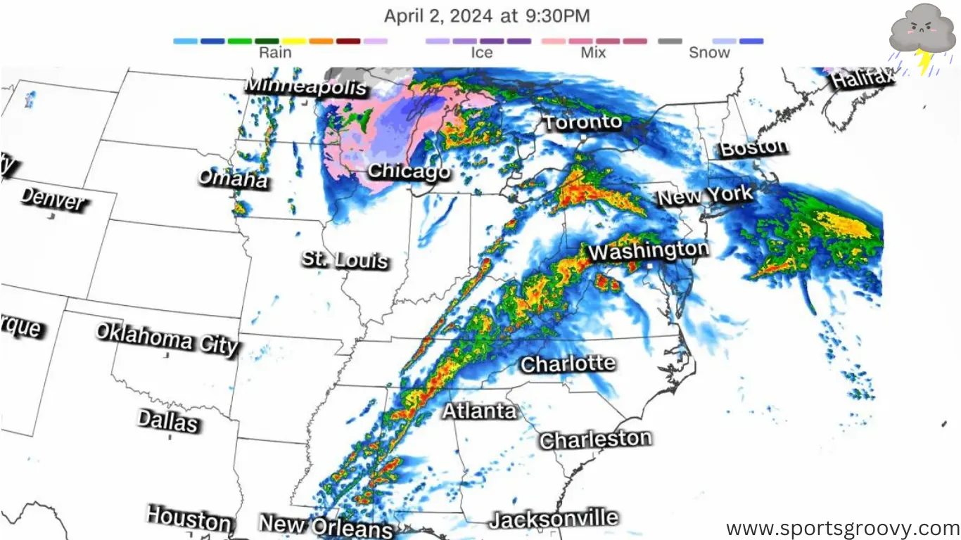
Some Kentucky counties are on tornado watch till 4 p.m. today. The risk of nasty weather is rising as millions in the eastern U.S. brace for severe thunderstorms. Many people got weather alerts because a dangerous storm is moving through Ohio Valley and the Northeast. We’re talking strong winds, big hail, and possibly tornadoes.
Big storms could happen in Ohio Valley, middle Tennessee, and Southeast on Tuesday. Storm Prediction Center said there might be strong tornadoes in the afternoon and evening.
Big storm hitting Ohio Valley now. 4 million folks near Ohio River have tornado watches until noon ET. Some storms might bring 90 mph winds.
More storms came Tuesday morning, with tornado and thunderstorm warnings. More bad weather expected in the afternoon and evening.
The National Weather Service said on Tuesday that according to forecast there’ll be heavy snow and strong winds in the Great Lakes and Northeast until midweek.
In Wisconsin, they’ve issued a winter storm warning from 1 p.m. Tuesday to 1 p.m. Wednesday, as per sportsgroovy.
In the next day, brace for a bunch of heavy, wet snow and gusty winds up to 40 mph. Roads will be slippery. Snow will keep falling in northeast Wisconsin till Thursday, then it’s sunny on Friday.
Watch out for high winds and hail in central Indiana and Ohio. They’re saying storms might even whip up tornadoes in Indiana. WCMH-TV in Columbus, Ohio, is saying there’s a slight tornado threat.
Preparation for storm
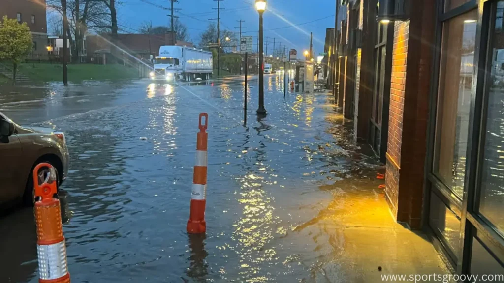
Be careful of flooding too. They’re watching 16 million folks from Illinois to Pennsylvania for floods on Tuesday. The worst flooding could hit parts of the Ohio Valley with heavy rain coming down hard. Could even lead to flash floods.
With all this rain, be ready for flooding in the lower Great Lakes, Ohio and Tennessee valleys, and central Appalachians till Wednesday morning. It might flood streets and small streams.
On Wednesday, look out for severe storms hitting the mid-Atlantic and Florida. There’s another low-pressure system coming to the mid-Atlantic coast bringing heavy, wet snow and sleet to the Northeast from Wednesday afternoon to Friday. Upstate New York and northern New England will get hit hard with snow, making travel tricky.
And don’t forget about Florida. They’re at risk for severe thunderstorms too from Wednesday into Thursday morning. Expect lots of lightning, strong winds, hail, and maybe tornadoes.
Monday was rough too, with storms, hail, and heavy rain bashing the South.


Pep Guardiola Benches Ederson: Big Call Ahead of Liverpool vs Man City Clash

Patrick Mahomes vs. Dak Prescott: How Their Contracts Compare

Sophie Cunningham Hopes to Join Forces with Caitlin Clark in the WNBA
Dutch Fans in Blackface to Imitate Ruud Gullit, One Agrees to Stop

Ex Glamour Model Says Party with England Team Before Euros
Dubai Flood, Rain Turns Desert to Aquarium🌧️🐠
-
 Soccer6 months ago
Dutch Fans in Blackface to Imitate Ruud Gullit, One Agrees to Stop
-
 Soccer6 months ago
Ex Glamour Model Says Party with England Team Before Euros
-
 News8 months ago
Dubai Flood, Rain Turns Desert to Aquarium🌧️🐠
-

 Soccer6 months ago
Argentina vs Peru 2-0 Highlights & All Goals Copa America 2024
-
 Entertainment7 months ago
The Try Guys’ Journey From Four to Two
-
 NBA6 months ago
Celebrate with the Boston Celtics: Parade and Traffic Updates
-
 Soccer6 months ago
UEFA EURO 2024: Essential Guide and Key Information
-

 Soccer6 months ago
Vinicius Jr Scores Two Goals in Brazil’s Win Vs Paraguay in Copa America 2024
Pingback: 4.8 Magnitude Earthquake Rocks New York City and US East Coast - Sports Groovy
Pingback: Oklahoma Town Hit By Second Tornado in Two Weeks - Sports Groovy